Monday, January 22, 2007
Hackney Wick to Beckton:
Or should that be Highbury to Hackney Wick…
Where do we begin talking about this section of the walk? Getting to Hackney Wick was the equivalent of Frodo’s quest for The Ring, and not as picturesque. What should have been a straightforward train journey on Silverlink tested our resolve – trains running with 45 min delays, heaving platform (with a lot of undesirable characters!), and cancellations a go go. We caught a mega-packed bus instead to Hackney Wick; the only seats left were at the very back on the top deck with the sun on your neck through the back window - it wasn’t pleasant - hot and flustered however a very young sweet girl sitting opposite with her Dad cheered me up no end with her winning smile.
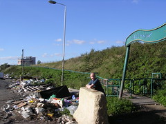
To make matters worse the bus got completely gridlocked in traffic. Tempers frayed, people exited the bus and we followed suit. All the traffic lights at a huge junction were out – just a shame that the coppers directing the traffic weren’t in any rush to clear the log jam of traffic which must have backed up to Highbury by time we got off the bus. We ended up walking the rest of the way to Hackney Wick – no mean feat I tell you –we covered 3 miles before we got to the start the next section of the walk (see Mark’s face on the picture at the Hackney Wick sign…) We were never as delighted to see the River Lea I can tell you…
Although we were a bit sick of the River Lea last time, we were glad to get back onto it after walking miles through some v dull housing estates. When we thought the walk would let us discover new parts of London we didn’t really have the back end of Homerton in mind!
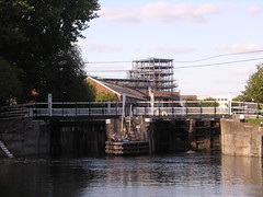
We carried on down the river and passed the studios where they used to film Big Breakfast – a little house and fake garden, no doubt still haunted with the ghost of Chris Evan’s cockfarmery. Blink and you’ll miss the house (it’s beside Old Ford Locks - an impressive double lock system in a large basin surrounded by trees where the river branches and heads down to Limehouse Basin. There were a couple of girls lunching on the lock who cheekily asked us if we would like their autographs – we were simply taking a photo of the locks, honest, and they weren’t no Sam Fox, Li Lo or Nicola from Girls Aloud

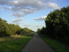
We walked a little further past a nature reserve and some half completed yuppie type flats that looked pretty nice but apart from the river they’re still in something of a shitttay area, so no thanks – and then left the River Lea and headed for our next section – The Greenway; a long raised path on a ridge that covers the Northern Outfall Sewer (acronym is NOSE with ‘e’ standing for embankment), a still functional 6 mile huge pipe that carries over 100 million gallons a day of London’s ahem effluent all the way from the city centre to the treatment works in Beckton. Apparently it’s the biggest sewage flow in Britain. It’s a pretty impressive engineering feat and it’s a great idea turning it into a pathway, though it does whiff a bit occasionally. Keep your eyes closely peeled for the signs leaving the Lea as it’s a sharp turnout. When we got to the path there were a few scally lads hanging around on bikes, they were harmless though and didn’t so much as give us a second look, phew!

Whilst on The Greenway we had to cross a confusing bit with lots of roads, railway tracks and little artificial rivers – the river is split into four for some reason – the Bow Back Rivers. The whole area however was still very light industrial and even worse than Hackney Wick – basically consisting of wasteland, scrapyards and great piles of fly tipped junk. It is amazing that space so close to London is basically just wasted and covered with mouldy, piss stained mattresses. Presumably the Olympics will turn this area around and Marshgate will be turned into a state of the art dolphin jousting arena or something. This was the worst part of the walk so far – esp when you have to go under a threatening, rubbish strewn, railway bridge and then walk up a very narrow path between some portacabins and some shrubbery. If this was a horror film you would be moidered here for sure, possibly by the inhabitant of one of the art studios we saw in the area, who had a load of shop window dummy arms hanging from the ceiling in a serial killer stylee.
Once on the Greenway proper it got more pleasant as it went along. Unfortunately it never actually got very interesting as it went along, being basically an incredibly long straight path with no variation, passing loads of very samey housing. The path crosses several busy roads, including Stratford High Street, an enormous and super busy dual carriageway where we managed to avoid the traffic but were then nearly run over by a lad riding his scooter on the pavement grrr.
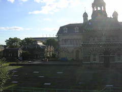
The first “Highlight” was (surprise surprise) sewage related – the Abbey Mills pumping house. A very OTT oriental Grade 2 listed Victorian building designed to pump sewage from one level of the NOSE to the next. It has been replaced by a modern facility but is still used by the water company as back up. It has been described as the “Cathedral of Sewage” but the “Victorian Railway Station of Sewage” is perhaps a bit more accurate. Unfortunately the sun was in the wrong place to get a good photo but we did our best.
The next highlight was when we left the path and headed to Plaistow High Street for a drink. The actual high street is fairly crappy with barely any shops or anything, but the pub, The Black Lion, was pretty nice and also friendly and busy. It’s an old coaching inn, apparently linked to dandy highwayman Dick Turpin !! (as is every coaching inn in London, I’m sure) and with a long timbered gallery holding the bar and a courtyard etc. We had a quick Magners but couldn’t linger as all our transport related shenanigans had made us late and we were worried about it going dark before we finished. I would certainly recommend it if ever you are in Plaistow (thou I wouldn’t recommend being in Plaistow first place, sorry Plaistowians).
Back on the path we passed East London cemetery, it’s a bit boring as it’s a smart well maintained one, not a cool overgrown gothic one. After that it was relentless walking. More houses, a hospital, yawn... Boring with a capital B. We did see a hawk or something at one point, circling overhead, which was cool. In the distance we could see the giant guillotine shape of the huge Barking Creek Flood barrier, impressive in stature even thou it’s still 3 miles away – the end it was in sight!! Now walkers, keep a watchful eye out at this stage for 2 metal banners where you take your leave from the Greenway, and about time too. I’d hazard a wild guess that some ruffian pulled the Capital Ring sign down to keep people walking to the flood barrier.
Eventually we left the Greenway and headed to Beckton. We had never been there before and it is not really like London – an area of ring roads, modern housing estates and big boxy office developments that reminds me more of somewhere like Swindon or Milton Keynes. As you cross a footbridge make sure you look out for the giant slagheap of a former gasworks, known as ‘Beckton Alps’.
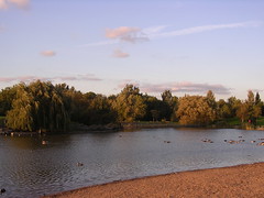
The walk then takes you through the lovely Beckton District park – complete with rare trees, a wild meadow area and a big duck pond but by now it was getting dark and we were both knackered and just wanted to go home. There is a big old disused dock right by the DLR (which, like all DLR stations, will always remind me of crappy BBC techsploitation series Bugs) but we’ll be exploring all that on the next section. We caught the DLR (which I love – being like a cross between a monorail and v crap roller coaster) back to Bank and were home in no time, especially compared to the hassle we had getting to the start of the walk in the first place.
Next: Beckton to Woolwich! Docks! EastEndery salt of the earth types (hopefully) and we finally reach the River Thames! woo hoo!
The rest of the photos are here
Or should that be Highbury to Hackney Wick…
Where do we begin talking about this section of the walk? Getting to Hackney Wick was the equivalent of Frodo’s quest for The Ring, and not as picturesque. What should have been a straightforward train journey on Silverlink tested our resolve – trains running with 45 min delays, heaving platform (with a lot of undesirable characters!), and cancellations a go go. We caught a mega-packed bus instead to Hackney Wick; the only seats left were at the very back on the top deck with the sun on your neck through the back window - it wasn’t pleasant - hot and flustered however a very young sweet girl sitting opposite with her Dad cheered me up no end with her winning smile.
To make matters worse the bus got completely gridlocked in traffic. Tempers frayed, people exited the bus and we followed suit. All the traffic lights at a huge junction were out – just a shame that the coppers directing the traffic weren’t in any rush to clear the log jam of traffic which must have backed up to Highbury by time we got off the bus. We ended up walking the rest of the way to Hackney Wick – no mean feat I tell you –we covered 3 miles before we got to the start the next section of the walk (see Mark’s face on the picture at the Hackney Wick sign…) We were never as delighted to see the River Lea I can tell you…
Although we were a bit sick of the River Lea last time, we were glad to get back onto it after walking miles through some v dull housing estates. When we thought the walk would let us discover new parts of London we didn’t really have the back end of Homerton in mind!
We carried on down the river and passed the studios where they used to film Big Breakfast – a little house and fake garden, no doubt still haunted with the ghost of Chris Evan’s cockfarmery. Blink and you’ll miss the house (it’s beside Old Ford Locks - an impressive double lock system in a large basin surrounded by trees where the river branches and heads down to Limehouse Basin. There were a couple of girls lunching on the lock who cheekily asked us if we would like their autographs – we were simply taking a photo of the locks, honest, and they weren’t no Sam Fox, Li Lo or Nicola from Girls Aloud
We walked a little further past a nature reserve and some half completed yuppie type flats that looked pretty nice but apart from the river they’re still in something of a shitttay area, so no thanks – and then left the River Lea and headed for our next section – The Greenway; a long raised path on a ridge that covers the Northern Outfall Sewer (acronym is NOSE with ‘e’ standing for embankment), a still functional 6 mile huge pipe that carries over 100 million gallons a day of London’s ahem effluent all the way from the city centre to the treatment works in Beckton. Apparently it’s the biggest sewage flow in Britain. It’s a pretty impressive engineering feat and it’s a great idea turning it into a pathway, though it does whiff a bit occasionally. Keep your eyes closely peeled for the signs leaving the Lea as it’s a sharp turnout. When we got to the path there were a few scally lads hanging around on bikes, they were harmless though and didn’t so much as give us a second look, phew!
Whilst on The Greenway we had to cross a confusing bit with lots of roads, railway tracks and little artificial rivers – the river is split into four for some reason – the Bow Back Rivers. The whole area however was still very light industrial and even worse than Hackney Wick – basically consisting of wasteland, scrapyards and great piles of fly tipped junk. It is amazing that space so close to London is basically just wasted and covered with mouldy, piss stained mattresses. Presumably the Olympics will turn this area around and Marshgate will be turned into a state of the art dolphin jousting arena or something. This was the worst part of the walk so far – esp when you have to go under a threatening, rubbish strewn, railway bridge and then walk up a very narrow path between some portacabins and some shrubbery. If this was a horror film you would be moidered here for sure, possibly by the inhabitant of one of the art studios we saw in the area, who had a load of shop window dummy arms hanging from the ceiling in a serial killer stylee.
Once on the Greenway proper it got more pleasant as it went along. Unfortunately it never actually got very interesting as it went along, being basically an incredibly long straight path with no variation, passing loads of very samey housing. The path crosses several busy roads, including Stratford High Street, an enormous and super busy dual carriageway where we managed to avoid the traffic but were then nearly run over by a lad riding his scooter on the pavement grrr.
The first “Highlight” was (surprise surprise) sewage related – the Abbey Mills pumping house. A very OTT oriental Grade 2 listed Victorian building designed to pump sewage from one level of the NOSE to the next. It has been replaced by a modern facility but is still used by the water company as back up. It has been described as the “Cathedral of Sewage” but the “Victorian Railway Station of Sewage” is perhaps a bit more accurate. Unfortunately the sun was in the wrong place to get a good photo but we did our best.
The next highlight was when we left the path and headed to Plaistow High Street for a drink. The actual high street is fairly crappy with barely any shops or anything, but the pub, The Black Lion, was pretty nice and also friendly and busy. It’s an old coaching inn, apparently linked to dandy highwayman Dick Turpin !! (as is every coaching inn in London, I’m sure) and with a long timbered gallery holding the bar and a courtyard etc. We had a quick Magners but couldn’t linger as all our transport related shenanigans had made us late and we were worried about it going dark before we finished. I would certainly recommend it if ever you are in Plaistow (thou I wouldn’t recommend being in Plaistow first place, sorry Plaistowians).
Back on the path we passed East London cemetery, it’s a bit boring as it’s a smart well maintained one, not a cool overgrown gothic one. After that it was relentless walking. More houses, a hospital, yawn... Boring with a capital B. We did see a hawk or something at one point, circling overhead, which was cool. In the distance we could see the giant guillotine shape of the huge Barking Creek Flood barrier, impressive in stature even thou it’s still 3 miles away – the end it was in sight!! Now walkers, keep a watchful eye out at this stage for 2 metal banners where you take your leave from the Greenway, and about time too. I’d hazard a wild guess that some ruffian pulled the Capital Ring sign down to keep people walking to the flood barrier.
Eventually we left the Greenway and headed to Beckton. We had never been there before and it is not really like London – an area of ring roads, modern housing estates and big boxy office developments that reminds me more of somewhere like Swindon or Milton Keynes. As you cross a footbridge make sure you look out for the giant slagheap of a former gasworks, known as ‘Beckton Alps’.
The walk then takes you through the lovely Beckton District park – complete with rare trees, a wild meadow area and a big duck pond but by now it was getting dark and we were both knackered and just wanted to go home. There is a big old disused dock right by the DLR (which, like all DLR stations, will always remind me of crappy BBC techsploitation series Bugs) but we’ll be exploring all that on the next section. We caught the DLR (which I love – being like a cross between a monorail and v crap roller coaster) back to Bank and were home in no time, especially compared to the hassle we had getting to the start of the walk in the first place.
Next: Beckton to Woolwich! Docks! EastEndery salt of the earth types (hopefully) and we finally reach the River Thames! woo hoo!
The rest of the photos are here
# posted by Mark @ 1:31 PM 
![]()